Prisons as Internal and External Space: The cases of Lushun and Seodaemun


The study of prisons from a spatial aspect is an interesting one. There are the architectural studies, which analyse the shape of a building and never begin without first referring to the famous Bentham Panopticon, then there are the multitude of ethical and moral studies, as well as philosophical, historical, legal, the list goes on.

For my essay I am focussing specifically on two prisons under Japanese rule, Seodaemun in Korea and Lushun in Dalian (Manchuria, formerly Port Arthur). Both are brilliantly covered in Shu-Mei Huang and Hyun Kyung Lee’s work Heritage, Memory and Punishment: Remembering Colonial Prisons in East Asia. Their work covers all aspects of prisons, showing how prison architecture in east Asia developed through Western influences. Crucially, they show how this evolved not just in an architectural sense, but also in line with legal, judicial and penal reform itself.

What I am most interested in is the difference in prisoner treatment between Seodaemun and Lushun. As Huang and Lee state, Lushun was not originally built as a Japanese prison, but taken over after the defeat to Russia in the Russo-Japanese War in 1905. The plans for the prison had originally been drawn up by the head of the Russian Pacific Fleet, and so there is a clear visual demarcation in the architecture denoting the extent of the original Russian construction and the later Japanese additions.1 This is important to keep in mind, as Lushun was used to hold the captured Russian prisoners of war after 1905. Perhaps this was an attempt at keeping the prisoners aware of their defeat, but the accounts of those held there show that they were treated remarkably well. I argue that the location of Lushun in Manchuria is central to this, as it was seen as an already contested space- having gone variously through Russian, Chinese and Japanese control. Furthermore, the Russo-Japanese War was Japan’s first global conflict, and so Lushun represented Japan’s willingness to abide by the relatively new European treaties of human rights. I therefore argue that the treatment of prisoners in Lushun was not a case of Japan’s magnanimity to their fallen enemies, but a deliberate ploy to be viewed as civilised and modern by the rest of Europe, in order to prove their ‘enlightenment’ and modernisation.

The proof is clear when contrasted against the conditions and treatment of prisoners in Seodaemun prison. Unlike Lushun, Seodaemun was constructed by the Japanese imperial government after the signing of the Japan-Korea Protectorate Policy in 1905, which formally brought Korea under Japanese control2. It was therefore a clear symbol of Japanese Imperialism and their view of Japanese superiority. Huang and Lee argue that it was designed specifically to hold ‘“dangerous figures” such as political offenders’, with the ‘”objective” [own emphasis] of separating them from society’3. I argue that it was this viewpoint of the Japanese as superior to the Koreans that explains the mistreatment of those held in Seodaemun prison. Taking the spatial angle, it is clear that Seodaemun, being located in Korea and fully under Japanese control, was thus perceived as an ‘internal’ space compared to Lushun’s ‘external’ space.
  1. Shu-Mei Huang and Hyun Kyung Lee, Heritage, Memory and Punishment: Remembering Colonial Prisons in East Asia, Oxon, 2020, p. 57 []
  2. Ibid, pg. 76 []
  3. Ibid, pg. 77 []

Modern vs Traditional: Analysing sanitation efforts within China’s messy urban areas

‘China’s cities seem especially—in many respects increasingly—inhospitable to community self-determination and participation in environmental design’1

Urban Planning has proven to be difficult when accommodating a large population and according to Daniel Abramson within his article Messy Urbanism and Space for Community Engagement in China, there is a common theme of these urban areas becoming messy because of the lack of community engagement within urban development. However, to understand how messy urbanism is approached and improved, sanitation efforts enable a better insight as to how developers have been able to boost community spirt, while also cleaning up living spaces and streets. By the 1950’s China seems determined to clean up its urban spaces, and connect the public through the concept of being involved in improving sanitation together.

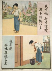
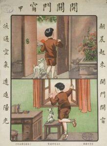
There are sanitation posters targeted at both children and adults to help them learn how to improve their hygiene and avoid the spread of diseases. These posters also provide insight towards Daniel Abramson’s argument which states that China would not follow the West in spreading out its population to smaller scale areas to avoid messy urbanism, instead he states that modernity was the point of interest rather than urbanity, and they were determined to push the cities into a modern state of living. Therefore, these posters from 1930 to 1950 show the progression of educating urban populations to enable the possibility of ridding the cities of messy urbanisation, while also allowing China to push towards its modern goal. To do this they needed social control of the population to enable these plans for larger streets and skyscraper buildings to become reality. Sanitation would change the state of minds and allow the community identity to accept the modernisation of their city. Below are two examples of how sanitisation was promoted towards children to catch germs and improve the living conditions of their homes.

Translation: I cover my mouth when I cough, and I spit into spittoon2

Translation: Let air circulate – open windows and doors in the morning3

‘Architectural chaos therefore also reflects a continuity and strength of community composition and identity. The coexistence of built-environmental disorder with community social order is extremely contradictory to the minds of professional planners and officials in China.’4

Furthermore, these plans to modernise China and allow space for wide streets and less enclosed living spaces could only go so far without demolishing Chinas traditional architecture. Instead, the traditional and modern began to coexist, which almost contradicted the idea of reducing messy urbanism. However, what can be argued is that through sanitation development and education, China improved its community values and enabled living spaces to change without changing. Those who lived within messy urban areas began to understand how to look after themselves and others to avoid spreading diseases, which would have been and still is a large concern within overpopulated areas. By regulating hygiene behaviours and introducing new sanitation protocols, messy areas could still modernise, while also being able to accommodate such a large population.

  1. Daniel Benjamin Abramson, Messy Urbanism: Understanding the “Other” Cities of Asia (Hong Kong University Press, 2016) p.218. []
  2. Hygiene Education for Children (U.S National Library of Medicine, 1950) []
  3. Hygiene Education for Children (U.S National Library of Medicine, 1935). []
  4. Daniel Benjamin Abramson, Messy Urbanism: Understanding the “Other” Cities of Asia (Hong Kong University Press, 2016) p.225 []

Cities as the frontier of propaganda: the creation of utopian/ dystopian space in Dalian in 1950s

Cities in Northeast China were critical locations for the industrial construction in the FFYP (the first five-year plan). Liaoning province was even called “the son of the republic”. As Liu Yishi demonstrates in his article, FAW became the icon of FFYP.1 Besides these physical constructions taking place in the Northeast of China, the construction of industrial cities also included the construction of propaganda and ideologies.  Propagandizing the spirit of revolution or revolutionary work was an important task for city planning. By referring to Bakhtin’s carnival sense of the world, I will demonstrate that the political propagandization comprised the carnivalization of public space, which led to the creation of dystopian space in China, especially during the period of Cultural Revolution.

In Liu Yishi’s Competing Visions of Modern, he quotes an article from Dongbei Ribao, a daily newspaper founded in 1945. It presents statistics on industrial production in the Northeast.2 With further investigation into this daily newspaper, one interesting phenomenon could be observed: the spiritual construction of citizens and industrial/ urban construction were treated equally in the socialist construction process in the Northeast. Many columns were devoted to explaining the importance of individual behaviour in maintaining sanitation and being a diligent worker in state-own enterprises. More on that, there were also patriotic education and lectures on the Party’s fundamental guiding principles.

Instead of only printing promotions in newspapers, cities were used as the media to spread these ideas. Two articles published in Dong Bei Daily Newspaper (Dong Bei Ribao) on 27 August 1950 discuss the importance of using the city as the centre to connect villages due to ‘its significant political influence on villages’ and how to exploit the function of cities in real life.  One article further explained that if a problem could be solved or figured out in the city, then surrounding villages could receive the same information so that problems would be solved thoroughly.3 The other article provided readers with eight specific methods which could be used in the propagandization work in Dalian. I will quote two of them here:

“Street radio – Radio is the best tool for propagandization/publicization in the city, it has great efficiency. Especially at the location where people gather, such as the shopping mall. Turning on the speaker, playing a CD first, attracting the attention of the masses, then giving a speech, but the speech needs to be concise and short, with incitation. Because people on the street are very mobile, some people leave, some people will come, and some will return. The speech could be repeated several times.”

“Festooned vehicle – using the festooned vehicles (big scooters or automobiles), hanging slogans around them, decorating them with beautiful flags, parading around. First, drumming attracts the public’s attention, then letting the publicist give speeches. After the speech, a short drama and peepshow could be following section.”3

The mutual characteristics could be derived: 1) the emphasis on the public space like streets and shopping malls; 2) the entertaining element in the process of propagandization, such as the short drama and the CD playing; 3) the political propagandization was hosted in a similar way to the celebration of festivals. These spatial practices match with Bakhtin’s carnival world, which includes the following characteristics: familiar and free interaction with people, eccentricity, carnivalistic mesalliance, and profanation.4  The gathering of a significant number of people in public locations blurs individual differences and makes ideas given by the speaker universal and applicable to all. Social hierarchy is eliminated. Everyone could be a part of the event. Public spaces also enable the occurrence of interaction and communication. The masses could react directly to the one giving the speech and communicate with many audiences surrounding them. However, this interaction is one-way since the audience cannot offer sophisticated and critical comments to the publicist. The only reaction they can give is either to cheer or to leave.

The addition of entertainment makes the masses subconsciously link political ideas and activities to drama, music and plays. Political propagandization is carried out in a format similar to operas and dramas. The request to use short, concise, and provocative language has a similar function to lines written by the playwriter to provoke the audience’s emotions so that they will experience the same feelings synchronously. Entertainment and the selection of public spaces where people’s everyday lives are carried out remind me of Zhang Jingsheng’s aesthetic society. In his Mei de shehui zuzhifa, Zhang proposed that music should be amplified and could be heard around the city, a subconscious form of education as people went about their daily routines.5 The political propagandization through radio and festooned vehicles are like Zhang’s music, played in the background of people’s everyday life, affecting them subconsciously. As L.A. Rocha states at the end of his article on Zhang’s urban theories, the aim of his utopian city was to reproduce the same minds and the same bodies.6 His aesthetics were basically authoritarian through and through.7 The underlying authoritarianism and the attempt to unify people’s minds could also be found in the propagandization work in Dalian.

This reshaping of public space later became the embryonic form of denunciation rally during the Cultural revolution from 1966 to 1976. While the core of this format of propagandization remained the same, the content upgraded from education of patriotism and internationalism to the public execution and criticism of people. Political propagandization was conceived as a kind of public performance. Public spaces become theatres and playgrounds. The seriousness was lost under that scenario, causing collective violence  more likely to happen. The utopian space, which could have been constructed if the masses learned from these teachings, transforms into a dystopian space where dehumanized activities and fearful behaviours take place, just like the performance of grotesque roles in carnivals if the political propagandization work is carried out in a carnivalized manner.

  1. Liu, Yishi. “Competing Visions of the Modern: Urban Transformation and Social Change of Changchun, 1932-1957.” Ph.D., University of California, Berkeley, 2011, p.117. []
  2. Ibid, p.111. []
  3. Dongbei Ribao, 27. August 1950. [] []
  4. “Carnivalesque” in Wikipedia, https://en.wikipedia.org/wiki/Carnivalesque [Accessed 15.10.2022]. []
  5. Leon Antonio Rocha, ‘A Utopian Garden City: Zhang Jingsheng’s “Beautiful Beijing”’, in The Habitable City in China: Urban History in the Twentieth Century, 2017, p.155. []
  6. Ibid, p.157. []
  7. Ibid, p.156. []

Blank Pages: The Great Kanto Earthquake and Japanese Occupied Manchuria

The Great Kanto Earthquake which leveled much of Tokyo and Yokohama in 1923 created an opportunity for reconstruction on an enormous scale and caused a shift in the population distribution as well as the aesthetic standards of the city.  The utopian approach to rebuilding Tokyo after the earthquake mirrors Japanese attitudes towards Manchuria while also serving as a stark contrast of utopian ideals.  

The event was described in the September 1923 issue of the American publication Japan Society as “The Greatest Disaster in History.”1 The earthquake and subsequent fire left “298,000 houses burned and 336,000 more shaken down,” in the journal’s initial report.2 A final estimate of its destruction was that around 45 percent of the structures in Tokyo were leveled, transforming it “from a bustling metropolis and imperial capital to a seemingly extinct city.”3 

4 

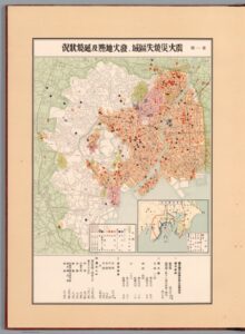
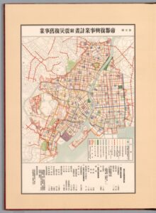
The scale of the destruction was interpreted at the time as “a moral wake-up call if not an outright act of divine punishment” but also, contrastingly, as a “golden opportunity.”5 At a time when utopianism and grand visions of urban planning were circulating in books like Ebenezer Howard’s Garden Cities of Tomorrow, the earthquake essentially rendered Tokyo a blank slate upon which to rebuild.  It literally flattened the city, creating “not only a unique, perhaps unparalleled opportunity to reconstruct Tokyo but the chance to arrest the perceived moral and ideological regress of Japan.”6 Efforts to not only reconstruct, but to renovate, beautify, and modernize Tokyo began.  By 1930 the products of these initiatives could be visibly traced on a series of maps produced by the Tokyo City Government which illustrated the results of projects dedicated to restoration and new construction of parks, schools, hospitals, roads, bridges, and electrical facilities.7 

8 

In addition to government efforts to rebuilt the city itself, the earthquake triggered a flight from the city center to the areas surrounding Tokyo, increasing the suburban population and decreasing the density of the city.  The suburb of Denenchōfu, planned and constructed in the years just before the earthquake, was modeled after the utopian vision of Howard’s garden city.  The timing of its construction (completed in 1923) and its location outside Tokyo caused its population to increase dramatically after the earthquake.9 This suburban population boom was widespread according to Japan Society’s December 1925 issue, which predicted that “Under the Greater Tokyo system, in which all of these suburban towns will be included in the City of Tokyo—and it is expected that this can be realized within the next decade or so—the City of Tokyo will have a population equalling that of London.”10

Denenchōfu serves as an example of the change in Tokyo’s population distribution as well as a new emphasis on the aesthetic qualities of the city’s spaces.  The architects of Denenchōfu placed a high value on the natural beauty of the development in accordance with Howard’s garden city ideal.11 The Tokyo government likewise invested in natural surroundings in its efforts to rebuild as evidenced by the excerpt in Japan Society’s May 1925 issue stating that “The Park Section of the Tokyo Municipality will plant 3,000 trees along streets in various sections of the city in May as part of the program to beautify the city.”12

This utopian conception of Tokyo post-earthquake as a blank slate on which to modernize infrastructure, disperse the population, and beautify the city parallels how some Japanese planners and intellectuals envisioned Manchuria.  The Japanese conquest of Manchuria after 1931, “provided a blank slate, or as city planners in Manchukuo put it, a white page, hakushi, on which ideal designs might be realized.”13 Ideal designs such as the Agricultural Immigrant Plan which envisioned utopian agricultural villages populated by Japanese farmers in northern Manchuria.14  In fact, “More than a few planners disillusioned by the resistance their plans faced in postearthquake Tokyo found planning on what they considered to be ‘blank pages’ in colonial Manchukuo more rewarding.”15 While the Agricultural Immigrant Plan was never realized, many architectural projects and modernization efforts were carried out in Manchuria.16 Like Tokyo after 1923, it served as a place in which to test utopian ideals.

Despite certain similarities in the conception of utopian plans, one of the stark contrasts between the “blank slate/page” of utopian planning in 1923 Tokyo and 1931 Manchuria was the ideology which accompanied it.  Unlike the aftermath of the Kanto earthquake in which the perceived “moral regress” included socialism, for those censored for their contrary politics in Japan, Manchuria offered a blank slate of a different kind.

  1. Japan Society, About Japan 1920-1928 (Internet Archive, 2021), https://archive.org/details/about-japan-1920-1928/page/n5/mode/2up. []
  2. Ibid. []
  3. Charles Schencking, “The Great Kanto Earthquake and the Culture of Catastrophe and Reconstruction in 1920s Japan”, in The Journal of Japanese Studies 34, no. 2: (Summer 2008), 296. []
  4. Zenjirō Horikiri, 1. Areas afflicted by the earthquake and fire disaster, places where fire broke out and circumstances driving the spread of the fire [map], Tokyo City Government, 1930, https://www.davidrumsey.com/luna/servlet/detail/RUMSEY~8~1~334402~90102430?qvq=q%3Apub_list_no%3D%2210808.000%22%3Blc%3ARUMSEY~8~1&mi=11&trs=38. []
  5. Schencking, “The Great Kanto Earthquake and the Culture of Catastrophe and Reconstruction in 1920s Japan”, 297. []
  6. Ibid., 297. []
  7. Zenjirō Horikiri, Teito Fukkō Jigyō Zuhyō, David Rumsey Historical Map Collection, Tokyo City Government, 1930. []
  8. Zenjirō Horikiri, 5. Program for the reconstruction of the imperial capital [map], Tokyo City Government, 1930, https://www.davidrumsey.com/luna/servlet/detail/RUMSEY~8~1~334398~90102426?qvq=q%3Apub_list_no%3D%2210808.000%22%3Blc%3ARUMSEY~8~1&mi=7&trs=38. []
  9. Ken Tadashi Oshima, “Denenchōfu: Building the Garden City in Japan”, in Journal of the Society of Architectural Historians 55, no. 2: (June, 1996), 146. []
  10. Japan Society, About Japan 1920-1928. []
  11. Oshima, “Denenchōfu: Building the Garden City in Japan”, 144. []
  12. Japan Society, About Japan 1920-1928. []
  13. David Tucker, “City Planning without Cities: Order and Chaos in Utopian Manchukuo”, in Crossed Histories (Honolulu, 2005), 55. []
  14. Ibid., 53. []
  15. Schencking, “The Great Kanto Earthquake and the Culture of Catastrophe and Reconstruction in 1920s Japan”, 323. []
  16. Louise Young, “Brave New Empire: Utopian Vision and the Intelligentsia”, in Japan’s Total Empire (Berkeley, 1998), 242. []

Manchukuo as an Imagined Space

The Japanese colonial project in Manchuria stands as being unique amongst the pantheon of colonial projects in China. Where the treaty ports were Chinese cities with portions carved out by western concessions, and fully foreign controlled regions like Hong Kong were limited in geographical scale, the Japanese puppet state of Manchukuo was expansive in scope and scale – more comparable to the settler colonization projects of Africa or Australia. Manchuria was subject to grand, utopian Japanese visions and designs – something that David Tucker explores in his essay City Planning without Cities, Order and Chaos in Utopian Manchukuo.[1] One particularly striking element discussed by Tucker is how Japanese urban planners conceptualized Manchuria. Tucker describes how Japanese urban planners explicitly saw Manchuria as a ‘blank slate’ – an empty, flat, virgin canvas on which they could paint their utopia.[2] This conception of Manchuria colors every part of the resulting plans – most strikingly in the wider geographical layout of the planned communities which take strict geometric shapes, with no consideration for natural features, already existing communities, and economic viability.[3] This plan of standardized hamlets has a number of fatal flaws seemingly total and disconnected – but the concept of imagined space can help piece them together.

The thinking behind the hamlet plan represents a very explicit example of Henri Lefebvre’s concept of imagined or mental space in action.[4] As discussed by Lefebvre, mental space is conceptual in nature – it may be based on some set of guiding principles, perhaps even a conception of reality, but it is by its standard nature an unconstrained, uncontested space.[5] Lefebvre uses this concept to critique the assumptions and ideas of other academics, framing mental space as an unconscious prior.[6] This divide described by Lefebvre between the physical and mental space is extremely applicable to the manner with which Japanese urban planners approached Manchuria.[7] Tucker discusses how the urban planners did study the lifestyle of Japanese farmers and applied those lessons into their designs, but did so in a way that simplified and removed nuance from the lives of farmers.[8] This flawed conception of the lived experience of farmers was the basis for the geometric layout of proposed hamlets[9], something which fed into many of the other numerous flaws with the hamlet proposal, notably including its security flaws, economic flaws and logistical flaws.[10]

Where Lefebvre uses the concept of imagined space to expose the flaws and failings of academic ideas and theories – concepts that are difficult to ‘defeat’ with finality – imagined space is useful in revealing the links between the common elements between the varying flaws of the hamlet proposal. This is a textbook example of how spatial theory can be used to analyze colonial projects and urban planning – an while the implications of spatial theory may be somewhat obvious in this case, similar examples of flawed conceptions of imagined space can be found in other colonial projects of all shapes and sizes – from French Indochina to the British Raj to the wider Japanese Empire.

[1] Tamanoi, Mariko. “City Planning without Cities, Order and Chaos in Utopian Manchukuo.” In Crossed Histories: Manchuria in the Age of Empire, 53–81. [Ann Arbor], Honolulu: Association for Asian Studies ; University of Hawai’i Press, 2005.

[2] Tamanoi, Mariko. “City Planning without Cities, Order and Chaos in Utopian Manchukuo.” 55.

[3] Ibid. 58-62.

[4] Lefebvre, Henri. “Plan of the Present Work.” In The Production of Space, 1–67. Oxford, OX, UK ; Cambridge, Mass., USA: Blackwell, 1991.

[5] Lefebvre, Henri. “Plan of the Present Work.” 3-4.

[6] Ibid. 4-6.

[7] Ibid. 6.

[8] Tamanoi, Mariko. “City Planning without Cities, Order and Chaos in Utopian Manchukuo.” 62-63.

[9] Ibid. 66.

[10] Ibid. 66-71.

Forward planning: A comparison of population control in Manchuko and the Taiping Heavenly Kingdom

A common thread with ideas of Utopian cities is the importance of planning, especially town planning. In the context of Manchuko, these Utopian ideals were made possible through its conception as an entirely new city, a literal blank slate from which to build a perfect regime. However, as with all concepts of Utopia dreamt up so far, what seems perfect on paper is always difficult if not impossible to make reality.

Take two examples of a Utopian ideal: Manchuko, an area of China under Japanese control, and the Taiping Heavenly Kingdom of Korea. Both are examples of a Utopian ideal that aimed to create a perfect world order according to the leader’s ideas. Both enjoyed a large degree of success in their formative years, and yet both ended up struggling to maintain that order as the cities grew.

The greatest similarity I found between these two examples is that of housing and the settlement structure. Both were designed around a rigid system of strictly controlled numbers for houses, whereby the entire population was compartmentalised into numerical blocks of houses, streets, villages, and districts. The aim in both was to instil a sense of duty and order in the inhabitants as well as create stronger bonds. I argue that while this may have been the case for some, this tightly controlled system of planning set itself up for failure from the beginning as both cases failed to take proper account of population demographics and long-term planning.

Let’s compare the statistics. David Tucker sets out the numbers for Manchuko in his chapter City Planning Without Cities: Order and Chaos in Utopian Manchuko. Accompanied at every stage with clearly labelled diagrams, he shows the proposed outline of Manchuko. It was ordered into a system of hamlets, with each one surrounded by fields and woodland and bordered by a gated wall and moat1. Each hamlet consists of a community building with a central plaza, and rows of houses arranged around it. Each one would have 150 houses, with each household comprising 5 people and allotted 15 acres of fields. The scale then ascended with 3 hamlets forming a village of 450 households of 2250 people2.

Tucker states that these numbers were very carefully chosen as it was based on an assumption that 150 households of 5 people each would mean an average of about 200 working-age men to provide labour, who would be equally split between guarding and agricultural duties. The designation of 3 hamlets into a village would be enough to provide “a sufficient economic base for shared educational, cultural and administrative facilities”3

These numbers were roughly the same in the Taiping Heavenly Kingdom. Instead of villages, families were grouped together into 25 households, although the size of each household was not regimented4. What sets it apart from Manchuko is the religious aspect. As the name suggests, the Taiping Heavenly Kingdom was a religious organisation, and so the fundamental doctrine is very different from the economic foundation of Manchuko. Perhaps the most striking difference is Taiping’s absolute segregation of the sexes and total prohibition on sex even between married couples, punishable by death5. This appears to have been far more of a religious order than any attempt at population control, and in any case was dropped after the inevitable loss of morale.

What does need to be considered is the sheer scale of population that both Manchuko and Taiping had to plan for. At it’s height, Manchuko had a population of 300,0006. A sizeable number, but comparatively easier to plan for. Taiping, on the other hand, had at its greatest height up to 2 million people7. This is of course impossible to verify and includes people on the periphery who may have proclaimed themselves a follower but not actually lived in a Taiping-controlled city. Nevertheless, the numbers speak for themselves.

In both cases, then, it was not so much a case of a lack of planning, but of fundamental population oversights. Both Manchuko and Taiping were founded on a basis of control of growth; economic for Manchuko and religious for Taiping. For Manchuko, the tightly regimented, perfect-on-paper outline could never have worked in reality as it failed to account for pretty much all aspects of population demographics. Such strictly controlled numbers of households and villages may have seemed like it could have been added to as required, but it takes an all-or-nothing approach and so does not account for the ‘in-between’ stages. Especially for a campaign that aimed to entice Japanese citizens to move in huge numbers, it would have required huge levels of pre-emptive statistics to be able to successfully house the numbers they required and neatly sort people into such a system.

Taiping, in the same vein, placed huge importance on proselytising and enticing new converts. In this sense, it is a contrast to Manchuko as there was far more planning for the governmental and political control than on a daily level, with far vaguer outlines for the distribution of land and labour. The emphasis was on communal life, but without the same kind of structural, regimented divisions seen in Manchuko.


Both Manchuko and Taiping are therefore brilliant case studies of the difficulty an urban planner faces in trying to marry a Utopian ideal with the lived reality of the human population. Manchuko arguably enjoyed a greater degree of success due to the smaller population overall, while Taiping could not cope with the sheer overwhelming scale of its devotees. It would thus be interesting to take this discussion further, perhaps in a longer essay than the scope of a blog post allows.

  1. Tucker, David “City Planning Without Cities: Order and Chaos in Utopian Manchukuo” in Mariko Asano Tamanoi (ed)., Crossed Histories: Manchuria in the Age of Empire, p. 60 []
  2. Ibid, p. 61 []
  3. Ibid []
  4. Wm. Theodore de Bary (ed), Sources of Chinese Tradition, pg. 225 []
  5. Reilly, Thomas H. The Taiping Heavenly Kingdom: Rebellion and the Blasphemy of Empire, University of Washington Press, 2011, p. 142 []
  6. Tucker, pg. 53 []
  7. Philip A. Kuhn. “The Taiping Rebellion” in Cambridge History of China, p. 275 []

Establishing Taihoku: Critical Approaches to the Development of Taipei Under Japanese Colonial Rule 1920-1945

Taipei, on the northern peninsula of Taiwan, has been referred to as a ‘tripartite city’ by Joseph R. Allen, Professor Emeritus at the University of Minnesota.1 Under Japanese occupation, it arguably underwent a third layer of urban developmental influence. The island of Taiwan had been used to foreign influence, for as early as the 17th century, the island had been occupied by the Dutch Empire (known as Dutch Formosa). The island really rose to significance in the late 19th century under the control of the late Qing Dynasty. In 1877, Chinese restrictions on immigration to the island were lifted and Taipei in particular became a focal point for trade, development and activity.

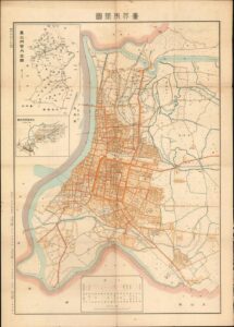
Although Liu Mingchuan, Qing Governor of Taipei until 1891 had implemented several key reforms to Taipei, it was not really until the Japanese colonists arrived that modernity really felt like it was on the horizon. Kodama Gentaro, the Japanese Governor General and Goto Shinpei, a civil administrator were the main architects of Taihoku’s development. Shinpei, who would later go on to serve as director of the South Manchuria Railway and Mayor of Tokyo, had been educated in Germany.2 Allen has alluded to the fact that Shinpei was also heavily influenced by Tokyo. In turn, Tokyo’s development had drawn many ideas from European cities such as Paris. Maps, such as the below from 1932, with ruler straight streets and a clear gridiron structure, really show how Taipei had been influenced by European colonial projects.

3

Taipei, even into the present day, as pointed out by Allen, has often considered itself a multicultural city. Away from Chinese mainland, and outwith the central power structure of the Chinese Communist Party, the city has always had a complex identity. Tan Hung-Jen and Paul Waley’s article ‘Planning Through Procrastination: The Preservation of Taipei’s Cultural Heritage’ discusses Dihua Street in Taipei, containing a number of late imperial edifices and buildings from the Japanese colonial period.4 The municipal government, property owners, stakeholders and citizens have all made an effort in varying ways to preserve these buildings as an important part of Taipei’s cultural identity. Additionally, buildings such as the Sotokofu, the main government building of Taipei and the Guest House (Táiběi Bīnguǎn), located in the city’s central district, were built by the Japanese and show a clear architectural and stylistic link to Europe. These buildings of grandeur, magnificence and opulence are typical of the domineering and grand style of buildings built under colonial and imperial rules. These buildings remain prominent today. The lack of ‘Chinese-ness’, as Allen describes it, can be much attributed to the Japanese era.

When one looks to understand the development of any space, place or spatial entity, one must understand and critically analyse the sources from which they are working. Allen cites the historian John Tagg, who maintains that even the ‘meaning’ from photographic evidence is dependent on the ‘discursive system’ and context within which it was taken.5When working with cartographic materials of Taipei as well, the same level of analysis must be used. For example, Allen’s article outlines the ‘lush’ maps of Taihoku the Japanese produced in the 1930s. Designed not with cartographic accuracy in mind, for they were meant to be understood and widely consumed ‘by women and children’, they show a bustling city, with buses, trains, commerce and activity. Taihoku is depicted as a well-run, prosperous and disciplined city, with all thanks to the Japanese imperial project. One image in particular, showing the city from a ‘bird’s eye’ perspective, looks out towards the sea and displays Mount Fuji standing tall and proud in the distance.6 To what extent are these depictions merely trying to emphasise the reward of colonial possession and desire?

The development of ‘utopian spaces’, especially in the context of colonial expansion, must always be considered carefully. For island cities like Taipei, their cultural identity, and the urban developments that often accompany them are politically contested phenomena. Is the island of Taiwan off the coast of China? Or is it off the coast of Japan? Many of the images that have come to light recently, raised by Allen in his article, have resurfaced only after exhibitions instigated by the Taipei City Cultural Affairs Bureau.7 With relations continuing to be strained between the ROC and the PRC, the nostalgia and romanticism of the many images from the Japanese period must be noted. Although clearly the Japanese prioritised the development of Taihoku, and indeed charted and archived much of their significant progress, one must always seek to understand why images have been constructed and re-presented in certain ways.

  1. Joseph R. Allen, Taipei: City of Displacements (Washington, 2012), p. 31 []
  2.  Louis Frédéric, Japan Encyclopaedia, (Harvard, 2002), p. 6 []
  3. 1932 Murasaki City Plan or Map of Taipei, Taiwan []
  4. Tan Hung-Jen and Paul Waley. “Planning through Procrastination: The Preservation of Taipei’s Cultural Heritage” The Town Planning Review 77, no. 5 (2006), pp. 531–55 []
  5. Allen, Taipei: City of Displacements, p. 33 []
  6. Ibid, p. 39 []
  7. Ibid, p. 17 []

What’s in a Roof? Architectural decision-making behind the Manchukuo Hall of State

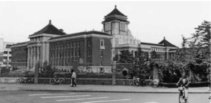
This blog post focuses on a picture included in Bill Sewell’s book “Constructing Empire: The Japanese in Changchun, 1905-45”. Sewell focuses on the roof of the Changchun Hall of State to illustrate the “Asian Revival” architectural style which inspired many of the administrative buildings built in Japanese controlled Manchukuo in the 1930s. The view of the building presented shows how architecture during this period sought to promote Asian stylistic choices over European ones, most clearly seen in the style of roof. However, the choice to incorporate Chinese as well as Japanese styles reflects the shift of the Japanese government to the idea of Pan-Asianism.

Sewell notes that the roof of the Hall of State is built in a Japanese style, called “Imperial Crown” style. This was characterised by a tented roof, adding an Asian finish to an otherwise European-inspired building. This is evident in the picture of the Hall, where the building without the roof is indistinguishable from a Western administrative building. However, Sewell argues that the use of towers and a gentle slope for the remaining rooftop resembled Chinese instead of Japanese architecture. This is initially at odds with the idea of a colonial government constructing buildings for administration, but signifies the specific style of Japanese colonialism which was employed in Manchukuo.

Since the building was meant ‘to represent the entire country as chief government offices’ it is significant that the building incorporates elements of Chinese architecture, instead of being simply a melding of Japanese and Western styles. Sewell cites Ryue Nishizawa as suggesting that the choice of a Chinese style was in an attempt to project symbolism of harmony and sedateness, both represented in the long roof architecture chosen. This in turn would imply that the Japanese colonial government was seeking some form of legitimacy in the eyes of the Chinese population, as opposed to the colonial governments led by European nations.

The decision to seek legitimacy from the Chinese population of Manchukuo fits with the idea of Pan-Asianism, a driving ideology of Japanese expansion during the 1930s. The movement sought to unite Asian ethnic communities politically and economically to combat European imperialism. As such, the end goal of Japanese colonies was assimilation into the wider state, as opposed to the Western model of colonial governance. This ideology was already present within the colony of Korea, which was becoming assimilated as a province of Japan at the time the Hall of State was being constructed. It should also be noted that this style of roof was present in architecture designed in Korea during the 1920s, suggesting that the Japanese government was in favour of rolling out this style of roof across its new colonies, to combat European design while promoting a unified Asian idea of architecture.

Overall, the roof of the Hall of State offers an insight into how architecture could reflect government ideology, and seek to project both power and legitimacy. In this case, the Hall of State’s roof was designed to oppose European building styles, while attempting to win approval from the Chinese population of the province, as an early step in the creation of a Pan-Asian utopian entity.


Sources

Kornegay, Nate, ‘Traces of the Imperial Crown Style in Colonial Korea’, Transactions 92 (2017), pp. 21-30.

Sewell, Bill, Constructing Empire: The Japanese in Changchun, 1905-1945, (Vancouver, 2019), pp. 64-106.

Picture in Sewell, Constructing Empire, p. 82.


Confucianism and urban planning in Changchun as the capital city of Manchukuo 1932-1937

When Zeng Guofan, the famous scholar and leader of the Hunan Army in the late Qing period, successfully took back Nanjing from the Taiping Heavenly Kingdom, one of the most prioritised tasks in his reconstruction plan was to build Confucian temples.1 Interestingly, Japanese colonialists’ naming of the newly constructed areas and its promotion of Confucian shrines and rituals of worshipping Confucius happened about sixty years later in Changchun coincidentally echoes with Zeng’s plan in Nanjing. In this blog, I will argue that Confucianism profoundly integrates with urban construction in Changchun, the capital city of Manchukuo, due to the reason that Confucianism is important to prove one’s legitimacy of ruling in China. It could consolidate the rule and is an essential alternative for the Japanese to construct a utopia in the urban spaces in Asia. Also, I want to address an exceptional characteristic possessed by Confucian temples, a form of unity in Lefebvre’s space of triad theory. The perceived, conceived space, perceived space and the space practised in a Confucian shrine reach a harmonious unification. This is one of the reasons why Confucian temples were preferred by a regime to build to consolidate its rule.

https://www.davidrumsey.com/luna/servlet/detail/RUMSEY~8~1~328360~90096829?qvq=q%3A%3D%22Manshu%CC%84koku%20Kokumuin%20Kokuto%20Kensetsukyoku%22%3Bsort%3APub_List_No_InitialSort%2CPub_Date%2CPub_List_No%2CSeries_No%3Blc%3ARUMSEY~8~1&mi=1&trs=2

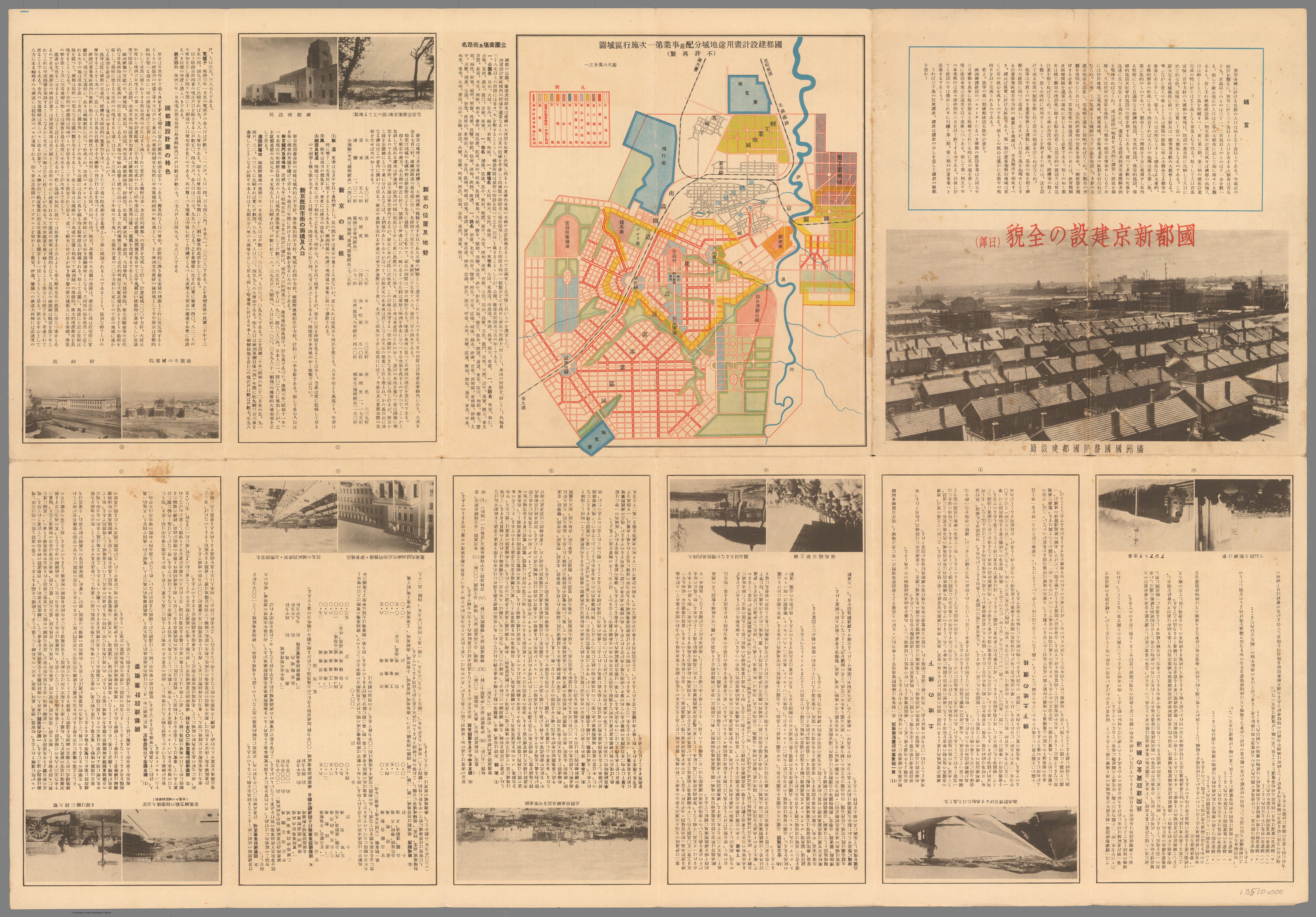
In order to find the trace of Confucianism in Changchun, I found a map with a detailed construction plan of Changchun. It was published in 1936 in Xinjing, another name for Changchun. As shown in the map, the names of the locations in the city centre were excerpted from Confucian classics. For example, Anmin street got its name from “Shuntian anmin” which means following the will of Heaven and bringing peace to the people.2

Since Confucianism was the most fundamental ideology for the rulers of China, it forms the most fundamental part of China’s social and administrative systems. In pre-modern China, to enter the administrative system, one must learn the classical text of Confucianism and then takes the civil examination to become a government official. On the social aspect, Confucianism assigns everyone who lives in the society a role to fulfil, like Confucius’s famous saying, “There is government when the prince is prince, and the minister is minister; when the father is father, and the son is the son.” Confucianism is the foundation for the order of society and the nation.

In the early 1930s, establishing order and control in Changchun was one of the most critical tasks for Guandong Army and the Manchukuo government after the Manchurian incident, and therefore Confucianism came to the front stage of Changchun. By looking into the historical context, we could know that in 1932, Japan was urgent to prove its legitimacy in China. In the North China Herald, published on 7 September 1932, there was an article with the title “Expedition to Manchukuo?” that reported the claim made by the Chinese government in Nanjing to take back Manchuria and the gathering of Soviet troops near the border of Manchukuo.3

In this map, these names excerpted from Confucian classics are particularly marked out, but buildings and locations such as the Ministry of Culture and Education and State Council were left out. They were only written in the columns printed beside this map. Actually, these government institutions were either located around Datong square or along Shuntian streets. The map tended to explicitly emphasise these public facilities, which were named after Confucianist ideology. The integration of Confucianism in the urban construction of Changchun entrusted Manchukuo and the Manchukuo government’s wishes that Manchukuo could become a prosperous and harmonious modern state under the teaching of Confucianism without following the trajectory of the west. Ironically, the order in Manchukuo, specifically in Changchun, was still maintained by Guandong Army.4

The other significance of the map is that it missed marking the location of Confucian shrines in Changchun. The most prominent Confucian shrine in Changchun is located near The Entertainment Place (歡樂地) on the map. Though many landmarks were named after Confucian classics, the map still overlooked one of the most critical things in practising Confucianism. It confirms what Yishi Liu argues in his article that from 1937 Confucian worshipping gradually lost its status in Manchukuo, as the Ministry of Culture and Education, which was in charge of worshipping Confucius, was reduced to a bureau and merged into the Ministry of Civil affairs.5 The promoted ritual of worshipping became the worshipping of Amaterasu. However, back in 1932, the ritual of worshipping Confucian was advocated by the first Prime Minister of Manchukuo Zhen Xiaoxu and supported by Guangdong Army, the true authority in Manchukuo.6 There was a trend of deterioration of the popularity of Confucianism in Changchun in the late 1930s when the Japanese gradually started to gain a more stable position in Northern China.

Finally, I want to argue that Confucian shrines are a space where the perceived, the conceived, and the practices could reach harmony without creating any unpredicted situation or function. Confucian shrines are built for worshipping Confucius; besides the rituals hosted by government officials or even the emperor, sometimes normal people could also go to the shrine for the same purpose. With thousand years of teaching Confucianism, the meaning of space and its ideology behind space became monolithic. An example of the construction in Changchun which created huge differences between the practices of the space and the space conceived is the National Founding University (Kendai) in Changchun, which was built as a pan-Asianist institution to breed the leader of future generations who would lead the revival of East Asia. But this eventually resulted in disillusionment amongst the best educated and highly expected people toward the nation-founding ideals, and some even turned themselves against the Japanese.7 Many secret anti-Japan activities were active in Kendai, such as the forbidden-book reading association. Compared to Kendai, Confucian shrines were a very ‘stable’ space with less probability of cultivating dangerous thinking or activities against Japanese colonial authorities. Confucian shrines, for hundreds of years, only had one straightforward function: to worship Confucius. With their close connection with the ruling class, and under the supervision of Guangdong Army8, it could be seen as a unified space of perceived, conceived and practised as a tool for the consolidation of the regime.

  1. Wooldridge, Chuck. City of Virtues: Nanjing in an Age of Utopian Visions (2015) Ch 4 “Zeng Guofan’s Construction of a Ritual Center, 1864-72”, p. 118. []
  2. Liu, Yishi. “Competing Visions of the Modern: Urban Transformation and Social Change of Changchun, 1932-1957.” Ph.D., University of California, Berkeley, 2011, p.103 []
  3. “Expedition to Manchukuo,” The North-China Herald, September 7, 1932. []
  4. Liu, Yishi. “Competing Visions of the Modern”, p. 62. []
  5. Ibid, p.73. []
  6. Ibid, p.69. []
  7. Liu, Yishi. “Competing Visions of the Modern”, p.24-25. []
  8. Ibid, p.69-70. []

Integration or Acknowledgement of Indigenous Communities: Raffles Town Plan of Singapore

This blog post focuses on the Raffles Town Plan, sometimes recalled as the Jackson Plan. It was formulated in late 1822, per Stamford Raffle’s vision by Lieutenant Philip Jackson for the town of Singapore. The concept of this plan was based on a pre-conception that Singapore would be a place of “considerable magnitude and economic importance”; therefore, its town plan needed to embody this newly fostered identity.[1]

Some may argue that Raffles had a unique vision when it came to town planning. His concept focused on three major philosophies: firstly, the integration of immigrants into formal town plans was essential. Communes for Indians, Chinese and other ethnic groups should be integrated so they were not left to develop separately. This, in turn, helped avoid public health problems like a lack of sanitation which would ultimately ensure uneven town development. If Singapore were to be successful, it, needed to grow as one. Secondly, a fort with parks and greenery should be at the centre. Forts gave the impression of prosperity, as did greenery. Third, communal harmony and ease of trade were factors that would ensure the growth and success of the town.

Below is the town plan of Singapore completed by Lieutenant Jackson. As can be seen by the notations on each section, Raffles wanted to reserve an area for a specific race or function. For example: from Fort Canning to the Singapore River and the sea beyond the Padang (labelled “Open Square”) for government use. Whereas other sections are entitled “European Town” “Arab” and “Campong” effectively segregating Singapore. Another important hallmark of colonial towns that can be identified are the wide and straight streets. These were justified by colonial rulers on the basis of public health and sanitation improvement; but in fact, were a tactic to prevent uprising or unrest from indigenous populations[2].

Diagram, engineering drawing

Description automatically generated

Plan of the Town of Singapore, Lieut Jackson, Survey Department Singapore, Survey Department Singapore (London, 1828).

The question I find myself asking is whether this town plan accurately depicts “integration of communities” as Raffles is said to have done. What becomes clearer upon second glance is that that “acknowledgement” may be a more fitting word to describe the town planning. What Raffles and Jackson have done is not integration as we would recognise it today. Rather an acknowledgement that other communities will need to live and exist in close proximity to their colonisers and for the success of the land as a whole (which was his objective “economic success” of Singapore) integration in the sense of acknowledgement was necessary. Singapore could not have been seen as a great powerhouse of industry nor economy if there were sections of the city that did not have sanitation and were not developed. One city, but separate communities is how I would describe Raffles vision.

[1] Buckley, C. B. (1984). An anecdotal history of old times in Singapore: From the foundation of the settlement … on February 6th, 1819 to the transfer to the Colonial Office … on April 1st, 1867. Singapore: Oxford University Press, p. 81. (Call no.: RSING 959.57 BUC-[HIS])

[2] Robert K. Home, “’Planting Is My Trade’: The Shapers of Colonial Urban Landscapes,” in Of Planting and Planning: The Making of British Colonial Cities ((New York: Routledge, Taylor & Francis Group, 2013), p.59