This blog post will explore how an evaluation of European mappings of the Tropics illustrates the development of Europeans’ concept of tropicality. As David Arnold notes, tropicality has ‘come to signify the conceptualisation and representation of the Tropics in European imagination and experience.1 Early European mappings produced a notion of tropicality associated with marvel and spectacle. However, when I analysed later maps, the Tropics is presented based on increasingly positivist scientific observations illustrating what Arnold notes as a shift toward ‘scientific tropicality’.2 European perspective of the tropical world was almost exclusively maritime, which meant that their original visions of the Tropics were always from the deck of a ship.3 This distant perspective meant that their tropical mappings often centered the coastline and encompassed a conceived exoticism that suggests, as David Arnold explores, ‘the Tropics were invented quite as much as they were encountered’.4
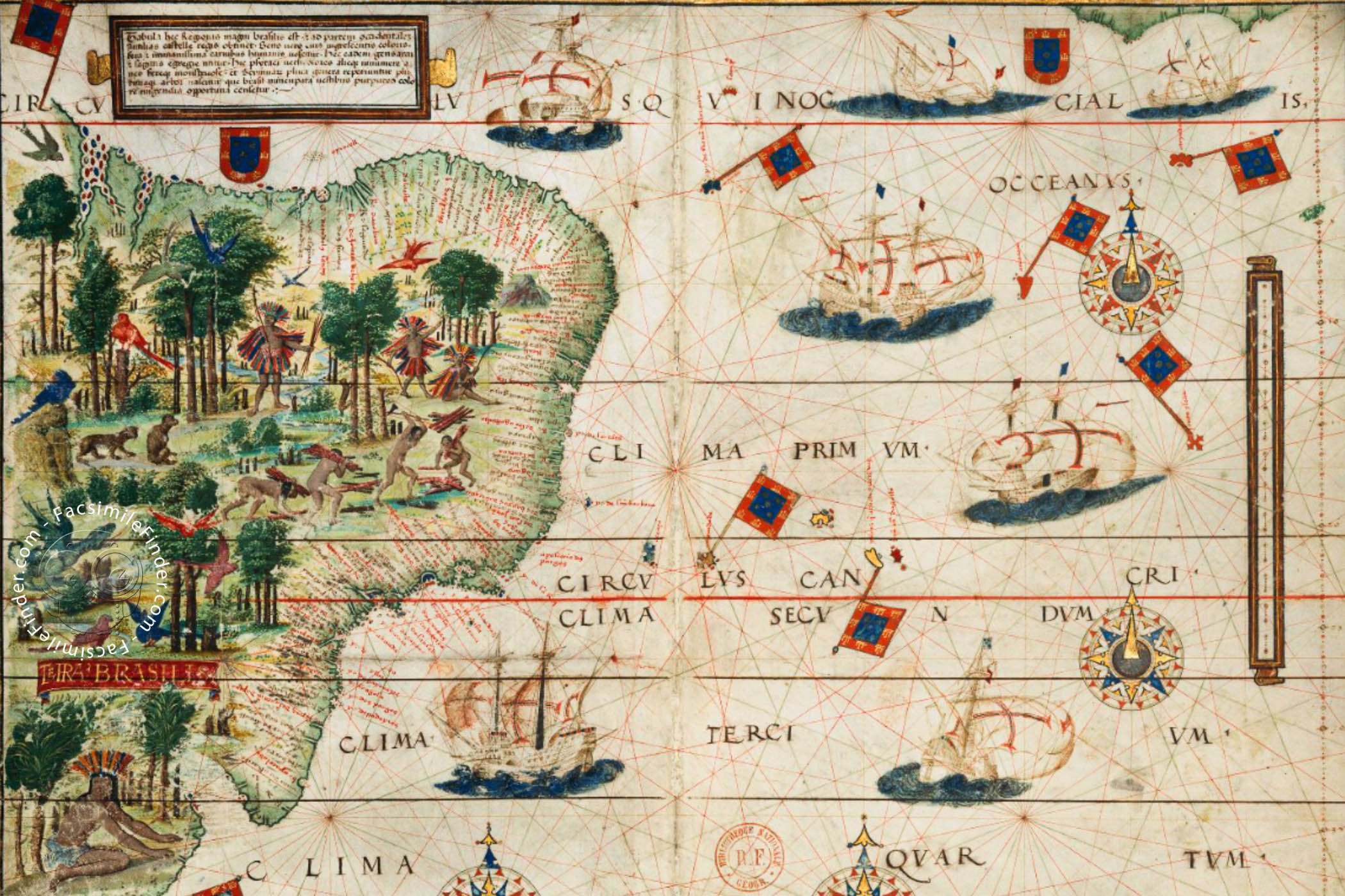
An example of Arnold’s claim that in early Orientalist thought, the Tropics were represented as an exoticised landscape can be seen through Denis Cosgrove’s analysis of the map Terra Brasilis in the Miller Atlas.5 This map was created in 1519, during the second decade of European contact with the Tropics. As Cosgrove notes, the map ‘presents to the European vision a place for witness and wonder, not a place to dwell’.6 The map is entirely pictorial and features scenes of nature and indigenous people. There are varied and exotic trees with many exotic fauna, such as multi-coloured birds, parrots and parakeets.7 The only labels on the map are on the coast, naming ports and bays that could have been areas for colonial conquest. This choice of labelling only potential areas that were relevant for settlement purposes highlights the lack of knowledge early European settlers had towards aspects of the Tropics that were not immediately related to their colonising process illustrating how the European notion of tropicality was based on imagination and a ‘bourgeois vision’.8 As Cosgrove writes, ‘the image is unmistakably tropical’,9 emphasising how it was this pictorial ethnographical type of knowledge that the founded the early European notion of tropicality.

Terra Brasilis, detail from the Miller Atlas, 1519.
In comparison, Heinrich Berghaus’s map created in 1852 highlights how Europeans’ understanding and the notion of tropicality developed. As Cosgrove explains, Berghaus’s map ‘offers no explicit moral judgements about the various environments and people it represents’.10 It conveys a tropicality based on geographical science rather than pictorial images. The map’s positivist observations highlights how the geographical experiences of Europeans in the Tropics developed the previous imaginative tropicality that was evident in the Miller Atlas. It provides evidence for Arnold’s claim that the notion of tropicality had shifted to involve a more systematic and scientific understanding of the tropics.

Nahrungsweise—Volksdichtigkeit, Heinrich Berghaus, Geographische Verbreitung der Menschen-Rassen (1852)
Comparing these two maps illustrates how Europeans’ visions and understandings of the Tropics developed. Initially, tropical mapping was centered around ‘the romantic constructions of imaginative tropicality’.7 However, as expeditions to the Tropics increased so did knowledge of the Tropics and this was reflected in how mappings and thus the notion of tropicality became more focussed on geographical science.
- David Arnold, Tropics and the Traveling Gaze India, Landscape, and Science, 1800-1856 (Seattle (Wash.): University of Washington Press, 2014), 110. [↩]
- Ibid., 112. [↩]
- Felix Driver, Martins Luciana de Lima, and Denis Cosgrove, “11: Tropic and Tropicality,” in Tropical Visions in an Age of Empire (Chicago: The University of Chicago Press, 2005), pp. 197-216, 202. [↩]
- Arnold, Tropics and the Traveling Gaze, p.5. [↩]
- Driver, Luciana de Lima, Cosgrove, “Tropic”, p. 204. [↩]
- Ibid., 205. [↩]
- Ibid. [↩] [↩]
- Arnold, Tropics and the Traveling Gaze, p. 6. [↩]
- Ibid., 204. [↩]
- Driver, Luciana de Lima, Cosgrove, “Tropic”, p. 208. [↩]