Translation or interpretation? Comparison between Lefebvre’s The Production of Space in English and in Chinese

A universal understanding of translation is that the translated text can never be one hundred per cent accurate. It is even more complicated to translate theories which are abstract and ambiguous. Scholars could produce different results of translation based on their own interpretations. Therefore, it is inevitable that the translator’s interpretation will affect the translated text. Their choices of phrases and the formation of sentences could reflect their understanding of the original text. I will compare the English-translated edition of Lefebvre’s famous work The Production of Space with its Chinese-translated edition and argue that the choice of words, phrases, and terms can reflect the development of studies on Lefebvre and the interpretation and the translator’s own understanding of the original text.

The first Chinese translation of The Production of Space was published in 2021. As the translator himself said in the preface that translating The Production of Space into Chinese was a difficult task, and many versions of translation in different languages were referred to.1 From the date signed at the end of the preface, we could know that the first draft of the preface was created in 2014, and its final edition was finished in 2021. It could be assumed that the translator spent approximately seven years translating this work. The English version was first published in 1991. There is a thirty-year gap between these two publications. The time gap affects the choice of words of the translators. One point worth noticing is that in the introduction chapter, Chinese translators use the term ‘trialectics’ (三元空间辩证法) to address Lefebvre’s theory of space triad. This term is never mentioned in the English translation because it only appeared until 1996 in an article written by geographer and urbanist Edward Soja on the theory of Lefebvre. Due to the late publication time and the evolution of research on Lefebvre, Chinese translators had more resources and published works about Lefebvre for reference. They could gain more knowledge and methodologies, which were developed in the past thirty years, to interpret Lefebvre.

No matter how many new terms the Chinese version adopts from the later research about Lefebvre, there is not much assistance for Chinese translators on the translation of the most fundamental concepts in Lefebvre’s theory . The choice of the word in Chinese could create huge differences. One of the critical terms of Lefebvre’s spatial theory is the title of the book “the production of space”. This term reveals his adaptation of Marx’s mode of production. Lefevbre claims that “space is a product”.2 In the Chinese version, ‘production’ is translated as Shengchan 生产(it literally means ‘production’, more frequently used to address industrial production, production in factories. )rather than Chansheng (also has the meaning ‘production’ but can indicate a broader range of production. If we look up the word ‘production’ in a French dictionary, its meaning in French and English is highly similar to each other. They can both indicate the meaning of Shengchan and Chansheng in Chinese. The possible explanation for this choice could be that choosing Shengchan over Chansheng demonstrates an emphasis on the Marxist influence in Lefebvre’s theory. As mentioned above, Lefebvre’s space theory has an inseparable connection with Marx’s mode of production. Marx’s production theory is translated as Shengchan in Chinese since Marx’s production does not have multiple potential meanings. It only indicates the activities of using resources to produce or make, and its meaning is closer to Shengchan than Chansheng. Shengchan guarantees the consistency of translated academic terms and is more suitable to the Marxian context in The Production of Space. Therefore, when more than one choice were displayed in front of the translators, they chose Shengchan. Also, due to the vital status of Marxian theory in China, the translator might be inclined to deliberately use Shengchan to make the Marxian influence more conspicuous to the readers.

Besides the title, differences between English and Chinses translations are also caused by different strategies of translation for the key terms. The most prominent case is the translation of the spatial triad. Their Chinese translation would cause more confusion to some extent. Representational space is translated as Biaozhengxing Kongjian 表征性空间, Xiangzhengxing Kongjian 象征性空间, Biaoxiangxing Kongjian 表象型空间 and Zaixianxing Kongjian 再现性空间. They are all translations of ‘representational space’. I will focus on the comparison between Biaozheng xing 表征性 and Zaixian xing 再现性 here. The translation of “representation” is a constant debate in Chinese academia. The phrase Zaixian appeared far earlier than Biaozheng in the discourse of translating ‘representation’. However, the use of Biaozheng gradually became more frequent than Zaixian.3  In the case of Chinese The Production of Space, the translators choose to use both of these two words, sacrificing consistency. The translators change the translated term according to the context. These two words could lead to divergence in interpreting Lefebvre’s representational space. Biaozheng indicates the embodiment of the complex symbolism of this concept; Zaixian, a traditional way of translating ‘representation’, could help a Chinese researcher to instantly refer it to the English or French word ‘representation’. In addition, Biaozheng, compared to Zaixian, is a term more frequently used in scientific disciplines. They have distinct academic contexts. Therefore, when a translator deliberately chooses one of them in the context of The Production of Space, the choice must be made based on his or her interpretation of the context.

The comparison between the English and Chinese translations of The Production of Space does not only indicate a linguistic difference between the two languages. Translation could reflect more information, such as the development of Lefebvre’s research over thirty years, debates on translation in Chinese academia and the unconscious emphasis on certain concepts. All of them could reveal the different academic interests and mindsets of the two academia. Sometimes a translated book could be read as more than just a translation, but also as an interpretative piece of the original one.

  1. Henri Lefebvre, The Production of Space, trans. Liu Huaiyu (The Commercial Press, 2021), p.xxi. []
  2. Henri Lefebvre, The Production of Space, trans. Donald Nicholson-Smith (Oxford: Basil Blackwell Ltd, 1991), p.26 []
  3. Yi Heng, Zhao, ‘Biaozheng or Zaixian? The distinction of concepts needs to be resolved immediately’, https://www.sohu.com/a/198947364_652768 {Accessed 30.9.2022}. []

Badly Drawn Maps

Badly Drawn Maps and what they can teach us

What makes a good historical map? Do detail and accuracy outweigh aesthetics and simplicity? Alternatively, what makes a bad historical map? Plenty of contemporary pop culture articles find entertainment in examining strange historical maps, assuming their scientific inaccuracy is something comical. But within these ‘inaccuracies,’ can we find historical insight we might have otherwise overlooked? This is the essential question Martin Bruckner seeks to answer. Don’t dismiss a historical map based on assumptions of what makes a ‘good’ or ‘bad’ map, argues Bruckner, rather we should explore why these definitions exist in the first place.

When examining maps, we make various assumptions about the relations of the map: the territory itself as existing independently of the map, north/south being top to bottom, east/west being right to left, and so on.[1] The “old” method of understanding historical maps, according to Bruckner, suggests that ‘good’ maps have unmistakable meanings, and ideals like truth and error are conceptually presented through them. They are the products of empirical science.[2] The map is a representation of a place. Yet, from the 1990s, ‘place’ began to be thought about more broadly, and scholars began treating maps as “subjective representations of social locations and human activities.”[3] This understanding also treats maps as places themselves.

In this view, maps are considered text-specific locales, or sites, shaped by a variety of contexts, ranging from the biography of the mapmaker to the geography of map production to the language of maps.”[4]

For Bruckner, however, our analytic approach to maps should go a step further than this text-based understanding. Historical maps are representations of places deeply endowed with sociality, being both man-made and “man-used.”[5] He argues for considering maps as products of social practice, shaped by all of the aspects that go into their creation; they are moulded by the engraver, painter, ink and paper suppliers just as much as the scholars and librarians who consume them.[6] Similarly, Matt Reeck views maps as “architecture of mind”. He argues they are a dynamic component of a historical process of commerce and settlement: “The advent of good maps is the advent of control over the land…”[7] For Reeck, mobility and movement of peoples is directly connected to cartography, and yet maps too often seek to standardize this; they aspire to “place places outside of time.”[8] Maps are social constructions, they push political agendas and represent societal attitudes. Their creation is often greatly influenced by power interests completely outside of the cartographic industry. Thus, can historical maps truly be deemed either ‘good’ or ‘bad’?


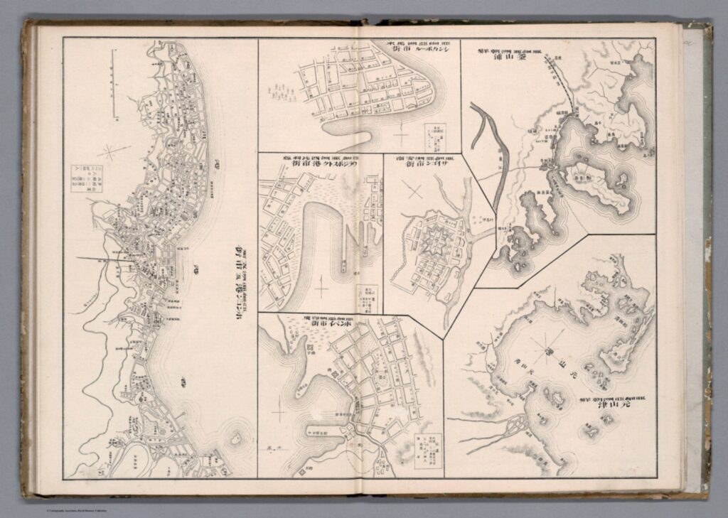
Taking Bruckner’s social approach, empirically ‘bad’ historical maps can now be considered useful and insightful in how they relate to issues other than physical geography. We can provide maps, seemingly objective creations, with historicity and time. Although developed in an American context, Bruckner’s approach can be equally applied to historical maps from East Asia. Examine this 1906 (Meiji 39) map by Japanese cartographer Yamane Akisato:


This atlas page shows 7 maps of various East Asian cities. Included (from left to right) are Hong Kong, Singapore, Vladivostok, Saigon, Bombay, Busan, and Wonsan. The maps show details of the city plan (roads, rivers, railways, etc.), the coastal outline, and major buildings, such as military stations. They are drawn in a simplistic black and white line drawing, which allows for a focus on the layout and structure of the cities and makes them easy to compare. These city maps were published in the atlas in between more detailed and coloured maps and illustrations, and the atlas includes text in both Japanese and Chinese. You may notice that these simple drawings are particularly ‘inaccurate’, or, in the very least, lacking detail. The coastline in the top-centre city (which I assume is meant to be Singapore, although it is difficult to tell) is comically simple, as if included in the compilation as an afterthought. In comparison, the coastlines of Busan and Wonsan on the right are drawn with more extreme detail. Deer Island in Busan’s Bay is especially noticeable, and details of smaller islands and water depth is even included. Although the map of Hong Kong (located far left) is denser, several of the streets are mislabelled in comparison to the reality of their positionality to one another. This strange picking-and-choosing of what details to include and what details to leave out by Akisato, the cartographer, is what makes this map so fascinating. If we now apply Bruckner’s social approach to analysing this map, it opens up the potential for historical interpretation and insight to be gained from it.


Drawn from the Japanese perspective in 1906 (Meiji 39), the map tells us how Japanese citizens might have seen and understood the world, and the importance of other cities in East Asia in comparison to their own. Placing these maps within the historical context of Japan’s activities in 1906, it makes sense for the map of Busan to detail so clearly the coastline and water depth around the city. Busan was a treaty-port which the Japanese held particular influence over around the time this map was published, and in which a strong Japanese presence had existed since the 15th century. Busan was the foothold through which Japanese forces established their control over the Korean peninsula prior to annexation in 1910.[9] It is likely Akisato may have visited Busan directly during his life, although not much is known about the cartographer himself and this is merely hypothetical. Regardless, as a Japanese citizen Akisato would have had, at the very least, more readily available access to information about Busan than to information about Singapore, for example, which was under British colonial control at the time.

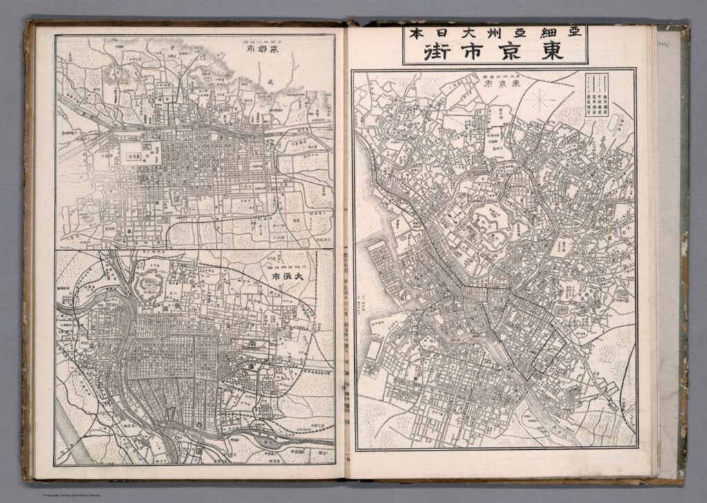
More acutely, these maps tell us how Akisato thought these cities should be presented in his atlas, and thus to those learning from his atlas. This highlights what he might have thought relevant, or in this case, not relevant, to be teaching other Japanese consumers about the wider world and about other cities across Asia, especially in comparison to Japan’s own major cities. There is a similar insert page in the same atlas that depicts Tokyo and its surrounding areas, Kyoto, and Osaka. These maps, meant to act as educational tools in the same way as the first 7 we examined above, are extremely dense, showing the grid block layouts of these cities in exact detail.


Considering the Japanese colonial context under which these maps were created once again, we can invoke Bruckner’s social approach to understand why these Japanese cities are presented more carefully. In the book How to Lie with Maps, Mark Monmonier argues that nations often enhance map features that support their point of view on the world and leave out details on the features that sit contrary to this.[10] Is this what is occurring here with Akisato’s atlas? Potentially, but further insight into this would require more research on his career and the publishing details of the atlas itself. At any rate, these maps are shaped deeply by Japanese colonialism and the power relations at play in East Asia in the early 1900s.

J. B. Harley maintains that historians of cartography often simply accept the cartographer’s suggestions of what historical maps are meant to represent, and advocates for greater scrutinization of maps as forms of knowledge creation. [11] The relationship between representation and reality contained within maps affects our relations to and perceptions of the material world, which is all the more pertinent considering a historical context far prior to the information technology era. These historical Japanese maps of various East Asian cities provide a good example of how we can scrutinize as Harley suggests, and they offer a great entry point for further research in this area.


[1] Searle, John. R., ‘Chapter 4: The Map and the Territory,’ in Wuppuluri, S. & Doria, F. A. (eds.) The Map and the Territory, Springer International Publishing (2018): p. 72

[2] Bruckner, Martin, ‘Good Maps, Bad Maps; or, How to Interpret A Map of Pennsylvania,’ Pennsylvania Legacies, Vol. 9, No. 2 (November 2009): p. 40

[3] Ibid, p. 40

[4] Ibid, p. 40

[5] Ibid, p. 40

[6] Ibid, p. 41

[7] Reeck, Matt, ‘A Brief History of the Colonial Map in India – or, the Map as Architecture of Mind,’ Conjunctions, No. 68, Inside Out: Architectures of Experience (2017): p. 185

[8] Ibid, p. 185

[9] Kang, Sungwoo, ‘Colonising the Port City Pusan in Korea: A Study of the Process of Japanese Domination in the Urban Space of Pusan During the Open-Port Period (1876-1910)’, Ph.D. Dissertation, University of Oxford (2012): p. 86

[10] Monmonier, Mark S., How to Lie with Maps, 3rd ed., Chicago: University of Chicago Press (2018): p. 132

[11] Harley, J. B., ‘Deconstructing the map,’ Passages, University of Michigan Library https://quod.lib.umich.edu/p/passages/4761530.0003.008/–deconstructing-the-map?rgn=main;view=fulltext [Accessed 09/10/21]


Primary Sources:

Akisato, Yamane, “Buson, Wonson, Vladivostok, Saigon, Bombay, Hong Kong.” from New Atlas & Geography Table (Bankoku chin chizu chiri tokeihyo), Nakamura: Shobido, Meiji 39 (1906) https://www.davidrumsey.com/luna/servlet/detail/RUMSEY~8~1~313791~90082699:Buson–Wonson–Vladivostok–Saigon-?sort=Pub_List_No_InitialSort&qvq=q:vladivostok;sort:Pub_List_No_InitialSort;lc:RUMSEY~8~1&mi=11&trs=12# [Accessed 08/10/21]

Akisato, Yamane, “Tokyo and environs, Kyoto, Osaka.” from New Atlas & Geography Table (Bankoku chin chizu chiri tokeihyo), Nakamura: Shobido, Meiji 39 (1906) https://www.davidrumsey.com/luna/servlet/detail/RUMSEY~8~1~313790~90082700:Tokyo-and-environs–Kyoto–Osaka?sort=Pub_List_No_InitialSort&qvq=q:author%3D%22Akisato%2C%20Yamane%22;sort:Pub_List_No_InitialSort;lc:RUMSEY~8~1&mi=21&trs=36 [Accessed 10/10/21]

Fengshui’s Conception of Space: The Material and Metaphysical Divide in Practice

A thought that has been brewing in my head since MO3354 (East Asian Intellectual History) was the nature of the Ontic/Epistemic divide in Eastern Philosophies. In my limited study of Buddhism, I believe that they can bridge this gap through the concept of Enlightenment (barring the Yogachara School). This divide is even more difficult to understand in the context of the Yi Ching and Fengshui. As Feuchtwang describes it, “Fengshui offers plausible hypothesis, but never proofs”. [1] It is possible that practitioners of Fengshui aren’t concerned with the epistemology of their craft, much less the ontic/epistemic divide. To look at Fengshui under this split draw away from the issues that scholars of the Yi Ching and Fengshui deem important. To consider the ontic/epistemic divide in Fengshui is not necessarily important, rather we should look at the material/metaphysical divide that is more evident in ancient and modern debates in different schools of Fengshui.

The most obvious split between more materialist and metaphysical perspectives on Fengshui is between the School of Forms and Orientations. The School of Forms emphasizes concrete topological features and draws an interpretation from material phenomena to decide whether a place has good Fengshui or not. The School of Directions is much more complicated and encompasses cosmological aspects including the Five Elements, Numerology based on the Bāgùa, and even planetary alignments. [2] What we can see here is a clear split between how Fengshui is conceptualized. The School of Forms sees Fengshui in a materialistic light, where the School of Orientations looks at it in a more metaphysical sense. This divide between emphasis on the material and metaphysical has interesting implications on the practical applications of Fengshui on spaces. There appear to be fewer examples of specific modern practices based on the School of Forms compared to Orientations. This is likely due to the intrinsic adaptability of each School’s basic principles.

In terms of application, the materialist leaning of the School of Forms has lent itself well to larger-scale planning and in areas where space is abundant. For instance, Ming Dynasty Beijing’s city planning seems to follow principles from the School of Forms. With their dragon-shaped city planning and the artificial hill behind the Forbidden City. The central line of the city forms a giant winding dragon from north to south, with two large gates as its eyes. [3] We also see the rules in the School of Forms being especially strictly adhered to in burial practices, particularly in places such as Taiwan; where space constraints are less severe and topological features abundant. Entire south-facing hillsides in areas north of Taipei are dotted with mausoleums and horseshoe-shaped graves. Based on these examples, it is evident that the School of Forms and subsequent schools that follow a materialist interpretation of Fengshui are more suited towards the planning of larger areas, incorporating and using topology on a larger scale.

On the other hand, the School of Orientations with its various modern interpretations such as the Bāgùa and Flying Star Schools has found itself being applied much more generously in places such as an office or household context. The Flying Star School, with its heavier focus on numerology, can be adapted towards floor planning. With favourable number combinations used for bedrooms and offices, and less favourable combinations for less important spaces. [4] There are also examples of small Bāgùa panels with a mirror in the centre being hung above main doors. In the Chinese diaspora of Singapore and Hong Kong, household Fengshui seems to be informed by general practices in the School of Orientation, especially in the placement and direction of furniture; especially beds. The emphasis on the metaphysical rather than the material meant that the School of Orientations’ practices were much better suited to modern adaptations and interpretations.

Thus, the divide in the School of Forms and Orientations has resulted in varied applications of Fengshui in spaces. With practices from the School of Orientations and its derivatives dominating modern approaches to Fengshui. It would be interesting to read further into Fengshui practices and the Yi Ching. Especially, to determine which Schools and their derivatives have been propagated more widely.

[1] Ole Brunn, An Introduction to Fengshui (2008), p. 90

[2] Ibid, p. 151

[3] Madeleine YueDong and Reginald E. Zelnik, Republican Beijing: The City and its Histories, (2003), p. 8

[4] Ole Brunn, An Introduction to Fengshui (2008), p. 52

Bachelard and Nenzi: Comparing Spatial Perspectives

In Gaston Bachelard’s Poetics of Space, he discusses the idea of the house as a place of imagination where subconscious memories are imbued in the physical structure. In his words, ‘he [the occupant] experiences the house in its reality and in its virtuality, by means of thoughts and dreams’.[1] Thus, Bachelard envisions a space of imagination where the walls of a building can not only be viewed solely on ideas of its function but also, as an embodiment of dreams’.[2] These ideas are also reflected in Laura Nenzi’s Excursions in Identity: Travel and the Intersection of Place, Gender, and Status in Edo Japan. In it, she argues the road is a site of individuals’ dreams and gives he or she a space to imagine a version of themselves or their place in society differently as they travel outside their fixed role within it.

Most of the tourism readings, like Japan’s pocketbook of travels, outlined routes, sites, and activities as recommended by the government, with a clear agenda or push to include certain historical places in the weaving of a larger national narrative. Nenzi, on the other hand, creates what one could term the ‘choose your own adventure’ outlook where she takes the journey of travelers and contextualizes them in the wide range of possibilities enabled on the road. Nenzi’s outlook can be extended towards the Meiji era where tourism rapidly expanded as Japan opened to the west. She discusses the role of mass consumerism which sees items like trinkets becoming important indicators of the trips undertaken which she argues expands the accessible nature of travel. However, this interpretation, while interesting, also pigeonholes the experiences and perceptions of places to a singular craft, institution, etc. This offers an interesting comparison to groups like the globetrotters, where the tourists shallowly engage with the people, places, and cultures they visit, the perception of the country produced from the trip will be undoubtedly be skewed.

However, there is a degree of difference as the globetrotters were usually foreign visitors thus their understanding of the country would significantly differ from visitors from other parts of the same country yet both experiences reflect the multiple realities of a single space. Thus, as Bachelard discusses the web of consciousness projected in a house, and Nenzi discusses the endless perceptions and imaginations able to occur on the road both emphasize the versatile meanings of one space.

[1] Gaston Bachelard, The Poetics of Space (Boston 1994), p.9

[2] Ibid., p. 15

Massey’s For Space Manifested in Yokohama Woodblocks

In Doreen Massey’s For Space, she argues against a static view of space. In her first chapter, she states space is a product of interrelations, is always under construction and is ‘the sphere of possibility of the existence of multiplicity in the sense of contemporaneous plurality’.[1] In this she means, space encompasses multiple possible trajectories at once.  She asks in her introduction, ‘what if we open up the imagination of the single narrative to give space for multiple trajectories? What kinds of conceptualization of time and space and of their reaction might that give on to?’.[2] Looking at the woodblocks produced upon the opening of Yokohama in the late nineteenth century, one can see examples that resonate in the answer to these questions.

As described by John Dower, the woodblocks which emerged with the developing commercial industry reflected a ‘dream window’ where people ‘let their imaginations run wild’ as they depicted not just what they saw but what they imagined.[3] Events or situations depicting Western and Japanese ways of life were a common theme in these prints however many were imagined and varied drastically depending on who the intended audience was. Western observers focused on the Japanese population with a preoccupation for capturing their quintessential essence and the Japanese did the same. As Dower points out, these different depictions are also impacted by the different mediums used, the Japanese using colorful wood prints while Westerners used black and white photographs or sketches.[4] Western periodicals like the Illustrated London News and Frank Leslie’s Illustrated Newspaper published engravings which catered towards a curious audience at home however, these publications became available in Japan shortly after the opening of the port.[5] Thus, the Japanese artists began to base their depictions off these images revising them to add their own unique style. The combination of printed foreign sources and colorful woodblocks created different perceptions of the same city which were then widely distributed to different populations within Japan and abroad, creating a variety of perceptions of not only Yokohama but the populations within it.

Artists like Sadahide (b. 1807) contributed to the growth of Yokohama woodblocks as a distinct subset of this Japanese tradition. These were widely available to regular Japanese citizens and depicted the international area and the people within it who would not be so accessible otherwise. Dower claims the city was, ‘a window looking out of Japan upon the unknown world of foreign nations that lay across the seas’.[6] Thus it didn’t matter whether or not the scenes depicted real events as they did develop a real image and perception amongst their consumers.

Here, Massey’s multiple trajectories theory is applicable to the different depictions creating different perceptions. While the city could be perceived as a drastically different place amongst these relationships, its impact was constantly shifting and changed by new works. Thus, through the lens of her theories, Western and Japanese perceptions of the city and people within it are part of the imagined space of Yokohama.

[1] Doreen Massey, For Space (Sage 2005), p. 9

[2] Ibid., p. 5

[3] John W. Dower, ‘Yokohama Boomtown: Foreigners in Treaty-Port Japan (1859-1872)’, MIT Visualizing Cultures, MIT

< https://visualizingcultures.mit.edu/yokohama/yb_essay02.html> [accessed on 10 December 2019]

[4] Ibid.

[5] Ibid.

[6] Ibid.